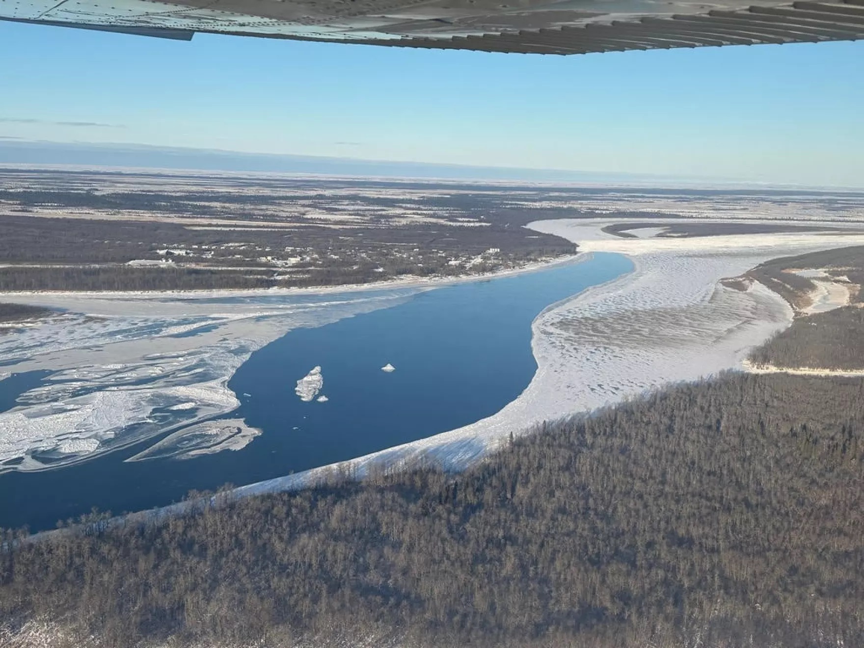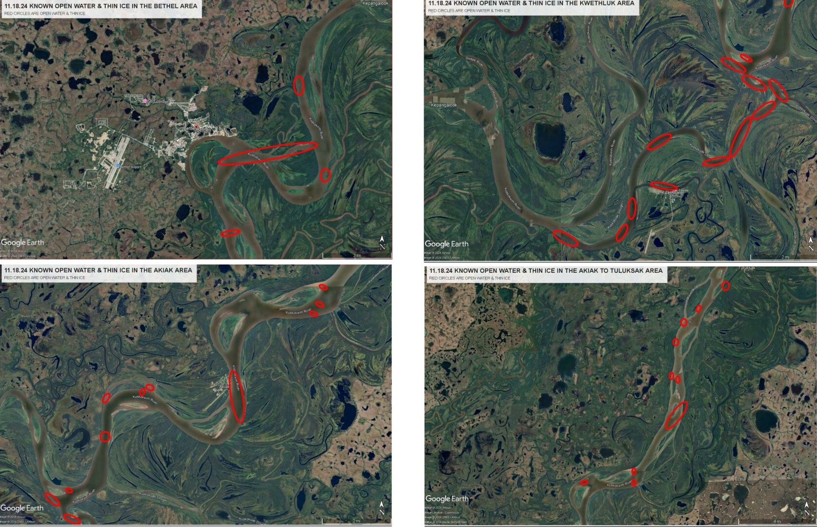
While the Kuskokwim River is starting to freeze, open water and thin ice are widespread along the well-traveled mainstem of the lower river, as well as around the tundra villages west of Bethel. The significant hazards posed by the river conditions led Bethel Search and Rescue to make the theme of its 2024 Kuskokwim River Aerial Survey “Danger Close.”
Bethel Search and Rescue member Mark Leary, who also leads the Kuskokwim Ice Road crew, called in to “Coffee at KYUK” on Wednesday to share what he saw on the Monday flight.
“Right now, the main river is no place to be. Nothing is marked. And there’s just too much open water out there to mark,” Leary said.
Leary said that surveying the river on the same day each year, Nov. 18, provides a valuable historical snapshot. This year’s aerial survey found that the edge of the ice was significantly closer to Bethel in comparison to 2023, a little more than 20 miles downriver.
“This year, (the) ice is further up than we’ve seen. It’s just there below the mouth of the Johnson (River) to Fowler Island in there,” Leary said.
But above Tuluksak to the middle river community of Aniak, the aerial survey found much better freeze-up conditions. Last year, where a 4-mile-long open hole was observed above Kalskag, that same stretch of river was found packed and frozen in this year.
Some of the most perilous conditions were observed in the area around Bethel. Immediately upriver, a massive hole extends from the east side of the island in front of Bethel, across the main channel, and up through Straight Slough.
Leary said that he is hopeful these well-traveled routes will be safe for travel in time for the busy holiday season.
“It doesn’t take very cold weather, but the river will heal itself little by little and we’ll be watching it,” Leary said.
Immediately downriver of Bethel, the survey found a large stretch of thin ice between Oscarville and Napaskiak, where a search remains underway for a missing man believed to have driven a four-wheeler into an open hole in the area on Friday.
Upriver, the survey observed a large area of thin ice and open water at the upper end of Schwalbe Island, while all of Kuskokuak Slough was a gauntlet of thin ice and open holes and completely unsafe for travel. The upper end of the Kuskokuak, and the main channel toward both Akiachak and Akiak are also currently major danger zones.
Farther upriver, there is a massive open hole directly in front of Akiak, while open water was also observed at the mouth of the Tuluksak River and just below Tuluksak where the back trail to Akiachak joins the river.
Headed west from Bethel, travelers have already reportedly broken trail to the tundra village of Atmautluak, rerouting around several open holes along the way. According to the aerial survey, there’s been less travel from Nunapitchuk and Kasigluk further to the west.
Kasigluk Search and Rescue president Wilson Twitchell said that travelers should resist the urge to deviate from established routes.
“No matter how much you’re tempted to take that shortcut or make a shortcut trail on, especially in the back roads, please refrain from making those shortcut trails because, you know, they’re not tested,” Twitchell said.

Leary, with Bethel Search and Rescue, said that the annual aerial survey is only part of the equation to ensure the safety of the vital frozen transportation network.
“The first people out on the ice every year are the fishers, the manaqers and the net-setters, and they’re out there every day manaqing, checking their nets and observing, observing the ice,” Leary said.
Once safe trails have been established, search and rescue crews will head out to make sure all remaining open water is marked in the traditional way using rows of willows fixed with blue reflectors.
According to Leary, a follow-up aerial survey will be conducted at some point before Christmas, though he said that additional flights could become necessary given drastic changes in weather conditions.
Residents of the region can report a missing or overdue person to 911, or call Bethel Search and Rescue at 907-545-4357 (545-HELP).
